A Sheep Debacle at Ruckle Provincial Park’s Grandma’s Bay

During a return trip to Salt Spring Island recently I visited Ruckle Heritage Farm in Ruckle Provincial Park. I was with a friend, lets call him Stephen, who lives on the island. As we didn’t have an abundance of time, I thought we’d just do a quick loop on the trail starting near the Henry Ruckle Farmhouse through to the Campground area. To start this journey we walked past the barns, the farmhouse, and several fields where I usually see sheep grazing. The last time I was there several curious sheep made a point of begging for treats through the fence, an endeavor which I presume proves successful with some visitors to the park. This time, however, about 6 of the sheep were outside of the fence. This proved to be interesting.

We continued down the trail behind the farmhouse and sheep barn and these 6 sheep happily tagged along behind us. It seemed likely they were not supposed to be there, but I figured that once we reached the part of the trail that went into the forest they would realize this wasn’t the journey for them. I was wrong. The sheep happily trundled along behind us under the tree canopy and through the Salal lined trail. There were some attempts to discourage this, but to no avail. Our first destination was Grandma’s Bay which was not far away. We reached the top of the stairs leading down to the beach with the sheep still right behind us. As we started down the stairs I figured the sheep would stop and realize the stairs weren’t a suitable adventure for them. I was wrong. All of the sheep clomped their way down the stairs and onto the beach with us.

arbutus trees at grandmas bay at ruckle provincial park

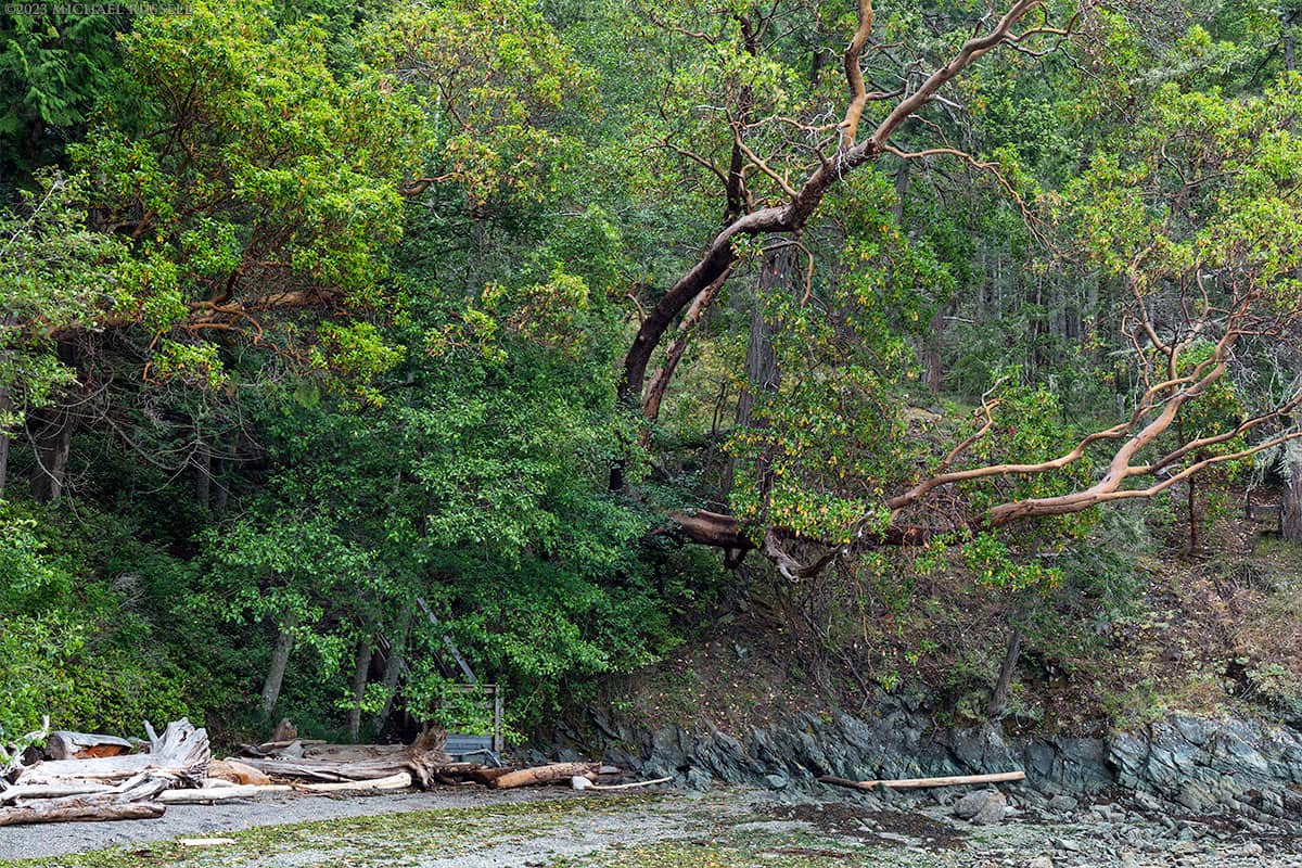
Large Arbutus (Arbutus menziesii) trees along the shoreline at Grandma’s Bay (Purchase)

The photo above shows the large Arbutus (Arbutus menziesii) trees that line the hillside at Grandma’s Bay and much of the island. You can also see the landing for the stairs. What you cannot see in this photograph, however, are the 6 sheep crowded around us checking to see if there are tasty morsels laying about on the beach or not. In retrospect this photograph is a lacking portrayal of the experience because of this. The story of the moment, the sheep, aren’t pictured at all. That said, and I’ll give the excuse that this may have been what I thought at the time, including them in this scene might be difficult as they were always so close by. If I backed up to get them in the photograph, they’d have likely mirrored my movement. Alas, this is not a photograph with sheep and ewe’ll just have to imagine the woolly, bleating tag-alongs without visual aid.

Once our time at the beach was done, perhaps after 10 minutes, we headed back up the stairs. Well, some of us anyway. I had though that the sheep would shy away from going down the stairs, and while this proved incorrect, I figured they’d have no issues attempting the return journey. For all I knew these sheep busted out of their split rail enclosures for a beach romp daily. Alas, there seemed to be some consternation about how ascending the stairs was to be attempted. Two did ultimately take the risk and galumphed quickly up the stairs to the top. The rest milled about in a restless quandary regarding this new stair problem. Ultimately, perhaps encouraged by the ringleaders who had left them behind at the bottom, they eventually decided to just climb the hillside next to the stairs and make their way back up to the top.

This gave our journey another problem. I felt slightly responsible for these sheep, and having almost left them marooned on the beach, we came to a fork in the trail. One presumably lead back to where the prison break originated, and the other was the rest of the loop trail through the campground and back to the car. All 2.5 kilometers (1.55 miles) of it. At this point we were only about 250 meters from the spot the sheep had joined our expedition. “Leading” them through the remaining 2+ kilometers of narrow trail, and into a shoreline campground seemed like an event best avoided. So at the junction the earlier pleasant attempts to dissuade further following degraded into louder statements of disagreement. At one point this took the form of a relatively polite, foot delivered shove to the backside by the aforementioned Stephen. This seemed to have the desired results, as offense seemed to be taken, and the gang of six no longer stuck close to us. The liberated livestock appeared to be favoring a journey back to the barn area to find the next batch of tourists who would hopefully be more forthcoming with inappropriate foodstuffs and adventures. As the shine had come off notions of accompanying us in our intended direction, we did not see any further attempt to follow us. We continued along the trail, taking in the views, the forest, and the campground.

beaver point lighthouse at ruckle provincial park

Beaver Point Lighthouse at Ruckle Park’s Campground (Purchase)

When we had reached the half way point through the campground a farm vehicle came by driven by Mike Lane – the operator of Ruckle Heritage Farm. He had someone else with him, and one or two very alert border collies. I waved them down and evidently there were some sheep reported in the campground. We pointed out they may have followed us, and had thought they were headed back towards the barn area. I purposefully failed to mention that they were on the beach with us in case this was some sort of unforgivable farm visiting transgression that would lead to consequences including possible chastisement. Evidently the apparent success of our discouragement attempts were only temporary, and the sheep carried on along the trail after us. Or perhaps this was a different roving band of farm escapees who had sought good times in the campground only to be reported by the current residents. People just aren’t as much fun as they look from the other side of the fence! I don’t know how sensitive sheep noses are but the scent of campground delicacies carried on the wind from the campground might be a tantalizing enough prospect that a jailbreak was deemed worthwhile. I’ll bet this wasn’t the first time this had occurred, and I’m sure they are occasionally aided by idiots who open gates they shouldn’t or otherwise interfere with normal farming operations. There are plenty of signs, but we know how that turns out – the sheep would sometimes do a better job at following them.

The Roadside Grocery

common raven stealing turkey egg at ruckle provincial park

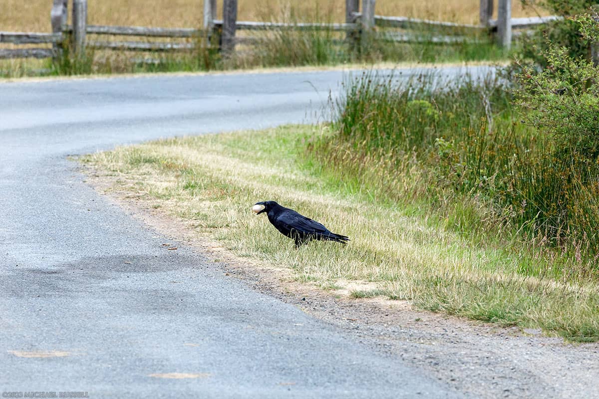
Common Raven (Corvus corax) with a stolen Turkey egg gathered from a roadside nest at Ruckle Heritage Farm (Purchase)

Another interesting event at Ruckle Farm was this Common Raven (Corvus corax) flying low over some of the road side ditches with apparent purpose. As I walked towards the barn area unaware of the sheep lying in wait – the raven disappeared into the foliage alongside the road. Then it popped out holding something in its mouth. I couldn’t quite tell what it was, so I made a few quick photos with my longer lens (luckily already attached to the camera), and zoomed in with the LCD. It looked like an egg! Searching the roadside it was apparent that some of the farm’s turkeys had been laying eggs in makeshift nests along the ditch. As Corvids tend to be really smart, I’m sure this raven is well aware that a fresh egg snack is available almost every day in that location!

For more photographs of Ruckle Heritage Farm visit my Ruckle Provincial Park Gallery.

Niagara Falls in Goldstream Provincial Park

Niagara Falls at Goldstream Provincial Park in British Columbia, Canada.

niagara falls at goldstream provincial park

Niagara Falls at Goldstream Provincial Park (Purchase)

I don’t make it to Vancouver Island nearly often enough. After a recent trip to Salt Spring Island I decided to forgo my usual return route of Swartz Bay via Fulford Harbour, and headed out of Vesuvius to Crofton on Vancouver Island to drive to Swartz Bay near Victoria and see what kind of things were along the way. I didn’t really plan this, and left later in the day than I thought I would, but I did manage to do some exploring on the nearly 100km meandering drive I made through southern Vancouver Island. I had never driven south of Cowichan Lake in the past so this was interesting. The highlight of this drive was visiting Goldstream Provincial Park for the first time and and wondering what a waterfall with the audacity to be named “Niagara Falls” looked like.

niagara falls and fallen trees

Niagara Falls and Fallen Trees (Purchase)

I had seen “Niagara Falls” on the map and knew Goldstream Provincial Park was a big attraction in the area. However, I’d done pretty much zero trip planning for this so I was flying by the seat of my pants all afternoon and evening. I didn’t have time for much of a hike, so the small waterfall symbol next to the Malahat Highway itself looked promising. To say I was pleasantly surprised is an understatement. Niagara Falls on Niagara Creek in Niagara Canyon (they really like that name!) is a very pretty waterfall at the end of a canyon surrounded by large Bigleaf Maple trees. I was quite lucky with the conditions as well. It was supposed to be overcast much of the day but things started to clear up a bit just as I arrived at the falls. The sun came out here and there, but I was able to photograph the falls in quite favorable conditions.

Many waterfalls I have photographed suffer from the same “why is there always a log!” phenomenon, and this waterfall was no different. I really didn’t mind the trees that had fallen at the base of the falls and elsewhere in the canyon though. The large tree at the base made for an interesting foreground. Overall they do tell a story about what happens here during high water flow events. Clearly the volume of water that comes over this falls during storms and other events is sufficient to carry these large trees downstream and into the canyon.

pool at bottom of niagara falls

Pool At Bottom Of Niagara Falls (Purchase)

With a waterfall as famous as Niagara Falls in Ontario, I would have thought I’d find some explanation why this falls was named the same. I wasn’t able to find anything. There is an alternative name for the falls, but it is “Golden Niagara Falls” which is still pretty similar. The canyon the falls are in is called Niagara Canyon, and the creek is Niagara Creek. Perhaps someone just thought it was a cool name.

niagara falls and bigleaf maples at goldstream provincial park

Niagara Falls and Bigleaf Maples at Goldstream Provincial Park (Purchase)

The more famous falls in Ontario is 51 m (167 ft) high while the Goldstream Provincial Park version drops 47.5 meters (156 ft) – so they are actually pretty close in height. This is where the similarity ends, obviously. Judging from what I’ve seen of the experience around the falls in Ontario, I’d rather visit the falls on Vancouver Island!

For more photographs of British Columbia’s Provincial Parks, visit my British Columbia Provincial Park’s collection of galleries.

Pileated Woodpeckers (Dryocopus pileatus) at Pacific Spirit Park

A male Pileated Woodpecker (Dryocopus pileatus) foraging for food in the moss on the forest floor at Pacific Spirit Park in Vancouver, British Columbia, Canada.

pileated woodpecker on forest floor

Male Pileated Woodpecker (Dryocopus pileatus) at Pacific Spirit Park (Purchase)

In 2022 I visited Camosun Bog in Vancouver to take a look at some bog plant species I hadn’t seen in a long while. My photos of Sundews and the other species there were more successful than I expected. Also a bit unexpected was the activity of two Pileated Woodpeckers (Dryocopus pileatus) which were foraging nearby. This is typically a fairly shy species, and these two moved around me without too much concern as to my presence, even when they were poking around on the ground nearby. The first photo here shows a male Pileated Woodpecker sitting on the ground having rummaged in the moss for available morsels. The red streak on the cheek indicates a male, and is an easy way to tell Male/Female apart.

pileated woodpecker on forest floor

Male Pileated Woodpecker (D. pileatus) at Camosun Bog (Purchase)

This is the same male hanging off the trunk of a tree. He climbed up the trunk, checking various spots for edible things, and then flew off into the forest. Pileated Woodpeckers in British Columbia feed off of a variety of wood-dwelling insects. Carpenter ants are the main food source in all seasons, and especially important during the winter months. Spruce budworm is also consumed, along with berries, nuts and fruits on occasion.

pileated woodpecker on forest floor

Female Pileated Woodpecker (D. pileatus) at Pacific Spirit Park (Purchase)

This is the female of the pair, looking around in the top of a broken off stump in the middle of Camosun Bog. I saw this female and the male check out this spot more than once, so I wouldn’t be surprised if there are regular routines in terms of foraging spots. The female later poked around in a tall tree in the middle of the bog, hammering a few spots with her beak, and then flying off in the same direction the male headed to earlier. Perhaps a nesting location. During most months of the year a pair of Pileated Woodpeckers are quite territorial, though this may relax slightly during winter.

pileated woodpecker on forest floor

Female Pileated Woodpecker (D. pileatus) at Camosun Bog (Purchase)

For more photographs of birds, visit my Bird Photos gallery.

Birding at Silverdale Creek Wetlands in Mission, BC

Common Yellowthroat (Geothlypis trichas) male perched on a branch at Silverdale Creek Wetlands in Mission, British Columbia, Canada.

common yellothroat at silverdale creeek wetlands in mission british columbia

A Common Yellowthroat (Geothlypis trichas) at Mission’s Silverdale Creek Wetlands (Purchase)

Years ago when I’d drive the Lougheed Highway in Mission, British Columbia frequently, I often noticed people standing on a small bridge in a wetland area. It was only last year I thought to look this up on a map, and then shortly after visited the Silverdale Creek Wetlands area for the first time. Silverdale Creek Wetlands is a nature preserve owned jointly by Ducks Unlimited Canada and the District of Mission. The municipal park and wetland area provides habitat for spawning salmon, birds, and other wildlife. The short 1.3km trail has good views of various ponds, Silverdale Creek, and the surrounding tree and grass covered areas. Aside from the usual waterfowl, the first thing I noted here were the birds I had not seen elsewhere.

The first photo above shows a Common Yellowthroat perched on a stick protruding from the edge of the main marsh pond. I had photographed a Common Yellowthroat once before, in Campbell Valley Park, but I did not have as clear a view of it as this one. This species is one I usually hear rather than see, but being one of the few birds here with a patch of yellow, they can be easy to spot if they venture out from the bushes and tall grass they seem to enjoy.

warbling vireo at silverdale creeek wetlands in mission british columbia

A Warbling Vireo (Vireo gilvus) at Silverdale Creek Wetlands (Purchase)

One species I spotted here that was new to me was this Warbling Vireo which perched in a rose bush just off the trail. Not quite as flashy as the Common Yellowthroat, but some subtle yellow in the plumage around the wings.

wilsons warbler at silverdale creeek wetlands

Wilson’s Warbler (Cardellina pusilla) at Mission’s Silverdale Creek Wetlands (Purchase)

Without moving my tripod I was also able to photograph this Wilson’s Warbler perched in a nearby willow. Just like the Common Yellowthroat, the Wilson’s Warblers do not seem to sit still, constantly flitting from branch to branch looking for tasty morsels. With a lot of yellow and the black cap on its head, the Wilson’s Warbler is easy to spot and identify. In addition to these species I’ve viewed and identified a lot of others including Pacific-slope Flycatcher, Goldfinch, Yellow-rumped Warbler, Spotted Sandpiper. Hoping for good photographs of some of those in the coming years.

mallard duck hen and ducklings walking across a trail

Mallard Hen and Ducklings (Anas platyrhynchos) (Purchase)

As with most local wetlands there are of course the usual species around as well. Silverdale Creek Wetlands has a lot of Canada Geese, Mallard and Wood Ducks, Great Blue Herons, and the occasional Bald Eagle and Osprey. I photographed this Mallard Duck leading her group of 7 ducklings across the trail from one pond to another. After a learning curve in regards to navigating the fence, all 8 were soon swimming in the other pond.

family of canada geese adults and goslings at silverdale creeek wetlands

A family of Canada Geese (Branta canadensis) snacking on wetland grasses (Purchase)

This Canada Goose family was swimming along the edge of the pond while the adults and goslings ate the tall grass along the edge. The goslings seemed to be learning how this goes with some having to make multiple attempts to grasp a blade of grass for ingestion. Often multiple goslings would go for the same blade of grass. This was fun to watch, while the adults kept a watchful eye over the whole proceedings.

For more of my bird photographs visit my Bird Photos Gallery.

Jug Island Beach Trail in Belcarra Regional Park

Jug Island from Jug Island Beach at Belcarra Regional Park (təmtəmÍxʷtən) in Belcarra, British Columbia, Canada.

jug island from jug island beach in belcarra regional park

Jug Island from Jug Island Beach (Purchase)

I recently made a post with photos from the picnic area of Belcarra Regional Park which is the part of the park I’ve visited most often. I had heard a lot about Jug Island Beach, and that it was one of those places that gets overrun in the summer with hikers and Instagram photo opportunity types. This is not the kind of spot I’m interested in when it is busy, as that gets in the way of why I enjoy the outdoors in the first place. So early April seemed like a good time to explore the trail on a weekday when there wouldn’t be much traffic. It worked – I think I passed maybe 5 people (and 2 dogs) at the most! The first photograph above shows Jug Island itself, and Raccoon Island further up Indian Arm, as seen from Jug Island Beach.

I’ve seen descriptions of the Jug Island Beach trail at Belcarra as being rather difficult, but that is rather subjective and relates to experience as well. I expected some up and down, and I got it. The trail is about 6km with about 250m (820ft of elevation gain) in total. Jug Island Beach is a rocky beach with a lot of intertidal life on the eastern side. I walked along the beach and photographed the view up Indian Arm below. From that end you can see the small Community of Brighton Beach to the north, Raccoon Island (part of the Indian Arm Provincial Park Marine Park), and the Buntzen Power Station #2 on Indian Arm to the right. The snow covered mountain in the background behind Brighton Beach is Mount Bonnycastle (1741m / 5712ft) in the Coquitlam Ranges of the Coast Mountains.

view from jug island beach looking north to brighton beach

View North of Jug Island Beach including Brighton Beach Community and Mount Bonnycastle (Purchase)

-click to enlarge-

The trail to Jug Island Beach is relatively easy to follow, and often the steeper parts are made up of rocky steps like those below. A lot of this forested area is covered in moss. I photographed this hillside covered in moss (with some Salal (Gaultheria shallon) mixed in) on the way back from the beach. Not just to take a break from the climbing either!

rock steps along jug island beach trail in belcarra regional park

Rocky steps along the Jug Island Beach Trail (Purchase)

An even more attractive moss wall has grown on this very large rocky slope just before you get to some wooden steps. I’ll admit that I was glad to stop here on the way back. I hadn’t climbed like this in a while and it didn’t bother me nearly as much as I expected, but the downhill parts always seem to get my knees. There were a few parts of this hike that reminded me that these weren’t the 20-something knees I took up Diez Vistas Trail etc a “few” years ago.

rock steps and wooden stairs along jug island beach trail in belcarra regional park

Rocky steps and wooden stairs along the Jug Island Beach Trail (Purchase)

Of all the photographs I made of the nature living around Jug Island Beach, this is my favourite. A lot of the rocks on the beach are covered in Rockweed (Fucus distichus) which is a species of brown algae that is common along shorelines in the Northern Hemisphere and an easy species to recognize. I liked how this one small rock covered in barnacles was the only surface nearby not covered in Rockweed. Most of my time walking along the beach was carefully scrutinized by a number of Canada Geese (Branta canadensis) who seemed to be a mix of slightly defensive of the area and curious what I was doing there. I’m sure they avoid it entirely when it is covered in people during the warmer months!

rockweed fucus distichus

Rockweed (Fucus distichus) and a Rock (Purchase)

For more photographs of Belcarra Regional Park and the surrounding area visit my Anmore & Belcarra Gallery.

Snow Squall over Golden Ears Ranges Mountains from South Langley

A snow squall over peaks of the Golden Ears Ranges near sunset – viewed from south Langley near High Point Estates.

snow squall at sunset golden ears ranges mount blanshard robie reid

Snow Squall at Sunset over the Golden Ears Ranges (Purchase)

-click to enlarge-

A few years ago I found a new spot in the southern part of Langley, British Columbia (near High Point Estates) to view the mountains to the north. Mount Blanshard (The Golden Ears) is the most prominent from here, as it is from most of Langley. Mount Robie Reid (right) is also frequently seen from various parts of Langley and Abbotsford. I waited until there was a good snowfall on the peaks and photographed the scene in February of 2022. Unfortunately, it was about -5°C and very windy so my large lens acted a bit like a sail and I wasn’t able to get any sharp images. This year I went back after a good snowfall in the mountains with much more success. Some of the snow I’d seen earlier in the day on the lower elevations had melted, but there was still some snow sticking on this evening in late March.

The panorama above shows a snow squall dumping some fresh powder during some sunset light on the Golden Ears Ranges (part of the Garabaldi Ranges) peaks, to the left of Mount Blanshard. To the right of Blanshard is a smaller peak called “The Defendant” (1884m / 6181ft), and then Mount Judge Howay (2262m / 7421ft) peeking out to the left of Mount Robie Reid (2095m / 6873ft). I was hoping for some interesting clouds but wasn’t counting on a snow squall like this. I watched it move westward, behind Mount Blanshard, and then get into a nice position just as some subtle sunset light warmed the colors up a bit.

mount blanshard aka the golden ears at sunset in winter

The Golden Ears at sunset as seen from south Langley (Purchase)

I made a number of panoramas here as the scene was perfect for it, but I also made a few “mountain portrait” style photos of some of the individual peaks. First up, Mount Blanshard aka the Golden Ears in the photograph above. I have many photographs of this mountain, from the south (Langley/Maple Ridge), the east (Port Coquitlam), and the west (Golden Ears Provincial Park). I like this view as I’m able to show more of the mountain itself than I am when I am a bit closer. From this vantage point I’m actually about 40 kilometers (25 miles) from Blanshard.

This next photo is mostly of Mount Robie Reid, but there is a bit of the more abrupt Mount Judge Howay showing up to the left of Mt. Robie Reid.

mount robie reid mount judge howay winter

Mount Robie Reid and Mount Judge Howay (Purchase)

The photograph below shows some peaks in the Chehalis Ranges with some nice sunset light on them. These are photographed from the same spot as the photos above, but they are approximately 70km (44mi) from that location. I was lucky to have some really clear air on this particular evening! Peaks here include Mount Clarke (2159m / 7083ft), Stonerabbit Peak (1858m / 6096ft), Mount Ratney (1967m / 6453ft), and Mount Bardean (1926m / 6319ft).

chehalis range peaks including mount clarke stonerabbit peak and mount ratney

Chehalis Range peaks including Mount Clark, Stonerabbit Peak, and Mount Ratney (Purchase)

For more mountain photographs please visit my Mountain Photos Gallery.

Four Photographs from the Backyard

I was putting together another “random” photograph post and it turned out 4/5 were from the backyard. A post of backyard photos made sense so you’ll just have to wait for #5.

Kanzan (Kwanzan) Cherry Blossoms

I recently visited Queen Elizabeth Park and Stanley Park in Vancouver and there were crowds of people gathered around the various cherry blossom trees in bloom at the moment. The tree in the backyard blooms later, probably in the first week of May, and I don’t need to deal with any crowds there! This variety is the Kanzan Cherry (Prunus serrulata ‘Kanzan’) which is also known as Kwanzan or Sekiyama. The Kanzan Cherry has deep pink, double-blossoms, and nice fall foliage. The backyard Kanzan tree’s flowers are a lot more ornate than the usual cherry blossoms I see around.

kanzan or kwanzan cherry blossoms with leaves

Kanzan (Kwanzan) Cherry Blossom with Leaves (Purchase)

Fireweed Flowers (Chamaenerion angustifolium)

These Fireweed (C. angustifolium) flowers are a favorite of Bumblebees and Hummingbirds in the backyard. Fireweed often takes over in new clearings made by fire (or clear cuts etc), hence the name. C. angustifolium is largely known as Fireweed in North America but is called Great Willowherb in parts of Canada. In Britain and Ireland it is known as Rosebay Willowherb or Bombweed. Other names include Saint Anthony’s laurel. While I was making this photo several years ago a hummingbird buzzed by my head several times as it was not happy I was in its territory. The Fireweed itself seemed unperturbed.

closeup of fireweed flowers

Closeup of Fireweed (Chamaenerion angustifolium) Flowers (Purchase)

Fall-bearing Raspberries

Organic fall-bearing raspberries in the backyard garden. Fall-bearing raspberries are sometimes known as everbearing raspberries because they can be pruned in a selective way in order to bear fruit during both summer and fall. Fall-bearing raspberries bear fruit on the current year’s new canes (primocanes). Raspberries are typically used in raspberry jams, in baked goods, on cereals, and in beverages.

fall-bearing everbearing raspberries fruit

Organic Fall-bearing Raspberry Fruits (Purchase)

Winter Heather Blossoms, Snow, and a Honeybee

In late winter or early spring the Winter Heather blooms in the backyard. There are a few local apiarists with Honeybee hives and the bees show up on good weather days as soon as there are blossom available. This year it snowed quite late in the season, and I made this photo of a honeybee on the flowers surrounded by snow. Not a usual combination in this area!

honeybee on heather flowers in the snow

Honeybee (Apis mellifera) on Winter Heather Flowers in the Snow (Purchase)

For more newly published photographs visit my New Images Gallery in my Image Library.

A few Photos from Belcarra Regional Park

The pier at Belcarra Regional Park (təmtəmÍxʷtən) near the main picnic area in Belcarra, British Columbia, Canada.

pier at picnic area of belcarra regional park on burrard inlet

Fishing and Crabbing Pier at Belcarra Regional Park (Purchase)

In November of last year I visited təmtəmÍxʷtən / Belcarra Regional Park in Belcarra, BC. I was hoping for some fall foliage, but I didn’t find all that much. Regardless of the fall foliage situation, there are always nice views from the pier at the main picnic area, shown in the photograph above. I did like the small hint of leftover color in these various tree species along the shoreline near the pier at Belcarra (below).

trees shoreline of belcarra regional park on burrard inlet

Trees along the shoreline of Burrard Inlet at Belcarra Regional Park (Purchase)

The photograph below shows another view, from 2015, looking towards the waterfront property along Burrard Inlet. The name of the park was changed somewhat in 2021, where the Tsleil-Waututh First Nation’s name for the area, təmtəmÍxʷtən, was added to the official name of the park. The first nations names on parks here are written in the International Phonetic Alphabet, which takes some getting used to. The approximate pronounciation of “təmtəmÍxʷtən” is “tum-tum-ee-hw-tun”.

belcarra waterfront homes property

Waterfront Property in Belcarra (Purchase)

Woodhaven Swamp

Many years ago when I was still using film I photographed a few scenes at Woodhaven Swamp. You can just glimpse this from the road, but it is a rather nice, short, walk around a swampy area filled with snags and the usual wetland plants and animals. When I arrived in November a Bald Eagle was sitting on one of the logs on the water, no doubt sensing my camera had a wide angle lens on it. The eagle was not courteous enough to stick around for the switch to my longer lens. Was still neat to see that close though. I completed the short loop trail along the Woodhaven Trail and made the photograph below of the boardwalk/bridge on the eastern side of the swamp.

boardwalk woodhaven trail at woodhaven swamp in belcarra regional park

Boardwalk along the Woodhaven Trail at Woodhaven Swamp (Purchase)

The edge of Woodhaven Swamp has a mixture of live and dead trees and a lot of wetland species. I saw a few Flickers here and there, no doubt making good use of the decaying wood for insect acquisition. The still waters of the swamp lend quite well to reflections, and I’ve always seen some interesting ones here.

tree reflections at woodhaven swamp in belcarra regional park

Tree Reflections at Woodhaven Swamp (Purchase)

The loop around Woodhaven Swamp is called the Woodhaven Trail which also connect to Sasamat Lake. I’d tried ot visit the lake but my favourite spots are now no parking areas and the main lot had a film production taking up most of the space so I just moved on. I should revisit this spring before the crowds!

boardwalk woodhaven trail at woodhaven swamp

Woodhaven Swamp Plant Life (Purchase)

For more photographs from Belcarra Regional Park and the surrounding areas in the Village of Belcarra and Anmore Village, visit my Anmore & Belcarra Gallery.